University*
M.Sc. Surveying & Geoinformatics
University of Lagos, Nigeria (Completed – 2024)

I’m a seasoned Surveyor and GIS Expert with over 15 years of field and academic experience. I specialize in drone mapping, GIS analysis, topographic surveys, and geospatial data processing. I am a Registered Surveyor
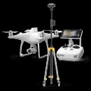
Hire MeUsing high-resolution UAVs, I deliver precise orthomosaic maps, digital surface models (DSM), digital terrain models (DTM), and 3D reconstructions for mines, urban planning, agriculture, and environmental monitoring.
Bringing designs to life through clean, responsive, and user-friendly code is my expertise. I develop fully functional web interfaces using modern frameworks and tools, ensuring seamless usability across devices.
I transform raw spatial data into actionable insights using GIS software like ArcGIS and QGIS—delivering digital maps, spatial reports, and geospatial solutions for planning and decision-making.
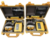
As an authorized dealer and consultant, I supply and provide technical support for GNSS receivers, total stations, UAVs, and accessories—helping professionals select and maintain the right tools.
I offer tailored training for individuals, teams, and institutions on UAV operations, GIS, CAD software, and field survey equipment—ensuring industry-compliant skills and productivity.
I advise governments, private firms, and academic institutions on the integration of spatial data, UAV systems, geodetic networks, and GIS platforms to improve decision-making, operations, and infrastructure planning.
 AutoCAD
 ArcGIS
 Google Earth
 Pix4D Mapper
 Metashape
 GNSS
GNSS
 UAV (Drone)
 Surfer
M.Sc. Surveying & Geoinformatics
University of Lagos, Nigeria (Completed – 2024)
B.Tech. Surveying & Geoinformatics
Bells University of Technology, Ota (2016–2019)
Federal School of Surveying, Oyo (2008–2010)
The Polytechnic, Ibadan (2004–2006)
Federal School of Surveying, Oyo (2001–2003)